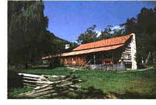
How to Get to Charit Creek Lodge
The Great Smoky Mountains offers accommodations at two lodges within the park which are accessible only by hiking or horseback -- Charit Creek Lodge and LeConte Lodge.
 How to Get to Charit Creek Lodge:
I-40 westbound: Take the Jamestown-Crossville Exit onto U. S. 127. Follow U. S. 127 north for 36 miles into Jamestown. Two miles north of Jamestown, take Highway 154 north to the intersection of Hwy. 297. Follow Hwy. 297 east to the Big South Fork National River and Recreation Area.
I-40 eastbound: Take the Jamestown-Crossville Exit onto U. S. 127. Follow U. S. 127 north for 36 miles into Jamestown. Two miles north of Jamestown, take Highway 154 north to the intersection of Hwy. 297. Follow Hwy. 297 east to the Big South Fork National River and Recreation Area.
I-75 northbound: Take the Oneida-Huntsville Exit 141 onto Hwy. 63. Follow Hwy. 63 for 21 miles through Huntsville. Turn right onto U. S. 27 and drive north 7 miles to Oneida. At the first traffic light, turn left on Hwy. 297 west and follow signs on Hwy. 297 to the Big South Fork National River and Recreation Area.
I-75 southbound: Take Mt. Vernon Exit 62, onto Hwy. 461 South for 19 miles to Rt. 80. Take Rt. 80 west into Somerset, KY. Take U.S. 27 south to Burnside, then onto 90 west for 15 miles, then take 90 Business through Monticello to 167. Take 167 south to Mt. Pisgah into Tennessee. You will be on state highway 154 south. Pass Pickett State Park Entrance, go 1 mile and then turn left onto Divide Road.
Hiking Trails to Charit Creek Lodge:
Charit Creek Hiking Trail
This is a very short route to the lodge. From the visitor center turn right onto Bandy Creek Road. When you come to the stop sign, turn right onto Hwy. 297. Follow Hwy. 297 to the TN 154 intersection. Turn right onto Hwy. 154. Follow Hwy. 154 to Divide Road turn right. Turn right on Fork Ridge Road then pass by Sawmill Trailhead; continue along the ridge top until the road ends at Charit Creek Hiking Trailhead and parking area. The trail is a quick 0.8 mile down. First, you descend stairs to the base of a bluff beside a wet-weather fall, cross the swinging bridge and hike down.
Twin Arches Loop Trail
This is the most popular trail to the lodge. Enter the park on Divide Road. Follow Divide Road for almost 3 miles before turning right onto the 2.4 mile access road to Twin Arches Trailhead.The trail to the base of the North Arch is only 0.7 mile. After taking time to explore both arches, you might prefer the shorter 1-mile portion of Twin Arches Loop Trail down to Charit Creek Lodge. However, the more adventuresome will want to proceed underneath the North Arch and follow the longer 3-mile portion of the loop to Jake's Place, and then down the valley. The trails converge at the bottom of the loop. There you'll cross a wooden bridge over Charit Creek to Charit Creek Lodge.
Sawmill Trailhead to Slave Falls Trail (You'll find directions to Sawmill Trailhead under the Charit Creek Trail heading.)
Slave Falls Trail is 4.7 miles and features Slave Falls and Needle Arch before it joins Twin Arches Loop Trail near Jake's Place and continues to the lodge.
Bandy Creek Campground Trailhead
From the visitor center turn left onto Bandy Creek Road. Bandy Creek Campground and Trailhead will be on your left in a short distance. Since there isn't a continuous hiking trail to Charit Creek from Bandy Creek Campground Trailhead, you'll have to weigh the hazards of walking on horse trails against the rewards of hiking along the Laurel Fork Branch of Station Camp Creek. If the weather has been relatively dry, the 11-mile Laurel Fork Loop from Jack's Ridge Trailhead is well worth the extra effort.
To reach Jack's Ridge Trailhead from Bandy Creek Campground Trailhead, begin by hiking northwestwardly along Bandy Creek Campground Road, then turning right onto the first road past the Clara Sue Blevin's Farmhouse. Turn left at each intersection thereafter until you reach the trailhead. Descend the steep, rocky road from Jack's Ridge and cross the branch to join a 4-mile stretch of trail going downstream along Laurel Fork. Near the confluence of Laurel Fork Branch and Station Camp Creek, you'll see a bridge that crosses Laurel Fork; do not cross it. Instead, continue straight ahead approximately 70 yards. Follow the trail to the left, marked by a sign saying, 'Charit Creek Hostel: 3.6 miles.' This trail will take you back to Fork Ridge Road, where you turn right and go a few yards to the Charit Creek Trailhead and Parking Area. From the parking area it is a quick 0.8 mile down Charit Creek Trail to the lodge.
For more information or reservations at Charit Creek Lodge, call 865-429-5704. Offices are located near the Applewood Farmhouse Restaurant at 250 Apple Valley Road in Sevierville.
| WELCOME TO GREAT SMOKY MOUNTAINS NATIONAL PARK Trip Ideas Great Smoky Mountains Facts Policies Institute at Tremont Order Your Free Visitor's Guide Transportation & Airports Local News Photo Tours • Fall Photo Tour • Roaring Fork Motor Nature Trail • Smoky Mountain Fall Foliage • Fall Foliage at Clingmans Dome • Fall Colors in nearby Villages • Fall in Wears Valley • Best Fall Hikes in the Smokies |
WHAT TO DO Attractions Biking Fishing Hiking Outdoor Adventure Scenic Drives and Rides Shopping Heritage, History, & Culture Nature Activities |
WHERE TO STAY Bed & Breakfast Cabins Camping Condos Hotels WHERE TO EAT |
4 SEASONS Winter Spring Summer Fall WEDDINGS Wedding Services Honeymoon Cabins |
Surrounding Towns: • Cherokee • Gatlinburg • Maggie Valley • Pigeon Forge • Townsend • Wears Valley CONTACT Contact Add Your Site Advertise
|