Balsam Mountain: The Quiet High Country of the Great Smoky Mountains
Tucked away in the northeastern corner of Great Smoky Mountains National Park lies Balsam Mountain, a place where elevation brings solitude, cooler air, and a sense of stepping back into a wilder Appalachia. While much of the park draws millions of visitors each year, Balsam Mountain remains one of its most overlooked and rewarding high-country destinations.
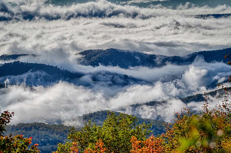
Rising above 6,000 feet in places, the Balsam Mountain area is defined by long ridges, narrow valleys, and dense forests that feel far removed from the bustling park entrances. Here, the air is noticeably cooler, the traffic fades away, and the sounds of wind and wildlife take over.
A Forest That Feels Northern
Balsam Mountain is best known for its spruce–fir ecosystem, a forest type more commonly associated with Canada than the southern United States. Red spruce and Fraser fir dominate the upper elevations, creating a dark, mossy canopy that stays damp and fragrant year-round. In summer, these forests provide relief from the heat; in fall, they are often wrapped in fog and color; and in winter, they can feel truly alpine, with snow and ice lingering long after lower elevations have thawed.
Because of this unique environment, the area supports wildlife rarely seen elsewhere in the Smokies. Birdwatchers seek out high-elevation species, while patient observers may spot black bears, deer, or signs of the park’s more elusive residents.
Balsam Mountain Road: A Drive into Isolation
Access to the area is primarily via Balsam Mountain Road, a seasonal gravel road that climbs steadily into the high country. The drive itself is part of the experience. As the road gains elevation, hardwood forests give way to evergreens, temperatures drop, and views open occasionally through the trees.
The road is typically closed during winter months due to snow and hazardous conditions, adding to the sense that Balsam Mountain exists on nature’s schedule rather than humanity’s. When open, it provides access to remote trailheads and backcountry campsites, making it a favorite for hikers and photographers seeking quieter corners of the park.
Trails and Backcountry
Hiking in the Balsam Mountain area is less about famous overlooks and more about immersion. Trails here tend to be lightly traveled, winding through forests that feel untouched despite their logged past. Backcountry campsites are available by permit and offer a rare opportunity to experience the Smokies after dark, when silence settles in and the stars feel closer.
This region rewards those who appreciate subtle beauty: mist drifting through fir trees, the scent of damp earth, and the deep quiet that comes only at elevation.
A Past Written in Timber
Like much of the Smokies, Balsam Mountain was heavily logged before the national park was established in 1934. Evidence of that era still exists in old road beds and altered forest patterns, yet decades of regrowth have softened the scars. Today, the mountain stands as a reminder of both Appalachian exploitation and recovery.
Why Visit Balsam Mountain?
Balsam Mountain is not for those seeking crowds or convenience. It is for travelers who value quiet roads, cool mountain air, and landscapes that reward patience. In a park known for its popularity, Balsam Mountain offers something increasingly rare: space to breathe.
For those willing to take the road less traveled, the high country of Balsam Mountain delivers one of the Great Smoky Mountains’ most authentic experiences.
Balsam Mountain is a prominent ridge and high-elevation area in the northeastern portion of Great Smoky Mountains National Park, primarily in Haywood County, North Carolina. It is best known for its cool climate, dense spruce–fir forests, and remote backcountry character.
Key Facts
• Elevation: Peaks in the Balsam Mountain area rise above 6,000 feet, with nearby summits among the higher elevations in the Smokies
• Ecosystem: Southern Appalachian spruce–fir forest, similar to Canadian boreal forests
• Climate: Cooler and wetter than lower elevations; snow and ice are common in winter
• Wildlife: Black bears, white-tailed deer, wild turkeys, and numerous high-elevation bird species
Balsam Mountain Road
• A seasonal gravel road that climbs from Big Cove Road to high elevations
• Provides access to remote areas of the park
• Often closed in winter due to snow and hazardous conditions
• Popular with hikers, birders, and backcountry campers
Recreation
• Hiking: Access to lesser-used backcountry trails
• Camping: Several backcountry campsites nearby (permit required)
• Birdwatching: One of the best areas in the park for high-elevation species such as the saw-whet owl and northern flying squirrel (rare)
Historical Context
• The area was historically logged before the park’s establishment in 1934
• Much of the forest has regenerated, though remnants of logging roads and camps remain
• Its remoteness helped preserve a quieter, less-developed character compared to other parts of the park.
Balsam Mountain Driving Trail has a picturesque picnic area and an overlook with restrooms.
Directions: From Soco Road in Maggie Valley go south on the Blue Ridge Parkway (towards Great Smoky Mountains National Park) for approximately 2 miles. Turn right on the Balsam Campground spur road and drive to the end of the paved road (about 9 miles). Continue onto Balsam Mountain Road (also known as Roundbottom Road). This is a one way, grass and dirt road known for its twists and a profusion of wildflowers. Due to road conditions, it closes on November 1 for the winter and reopens in April. Wind your way down Balsam Mountain to Big Cove Road and continue into Cherokee. This is a wonderful road for 4 wheelers and nature photographers.
From Heintooga, you can return the way you came or take the one-way Balsam Mountains Road to Cherokee. The first 18 miles are unpaved but in good condition for passenger vehicles (no buses, trailers, or motorhomes). It takes about an hour to return to Cherokee on the scenic Balsam Mountain Road.
Near the campground entrance, a short self-guiding nature trail provides an orientation to the area's northern hardwood and spruce-fir forest. Heintooga Picnic Area and Overlook are one mile beyond the campground. Restrooms are also available here. The overlook offers views of the vast wilderness where some Cherokee Indians retreated to avoid removal on the tragic Trail of Tears. From the picnic area you can either turn around and return the way you came or continue down the one-way, gravel Balsam Mountain Road. Driving time to Cherokee is about one hour via the Balsam Mountain Road which is maintained in conditions suitable for passenger cars.
| Trip Ideas Great Smoky Mountains Facts Institute at Tremont Transportation & Airports Local News Photo Tours • Fall Photo Tour • Roaring Fork Motor Nature Trail • Smoky Mountain Fall Foliage • Fall Foliage at Kuhowi • Fall Colors in nearby towns • Fall in Wears Valley • Best Fall Hikes |
WHAT TO DO Attractions Biking Fishing Hiking Outdoor Adventure Scenic Drives Shopping Heritage, History, & Culture Nature Activities 4 SEASONS Winter Spring Summer Fall WEDDINGS Wedding Services Honeymoon Cabins |
WHERE TO EAT Restaurants Farmers' Markets Recipe Cards Surrounding Towns: • Cherokee • Gatlinburg • Pigeon Forge • Townsend • Wears Valley CONTACT |
||